
Strong winds, heavy rain and cold temperatures have swept over much of the UK just days after Britons basked in a short-lived heatwave.
Parts of the country are forecast to see a month’s worth of rainfall on Monday alone, with the Met Office issuing weather warnings, saying the conditions could cause flooding, power cuts and damage to trees and other structures.
Nearly 40 “be prepared” flood alerts were active on Monday afternoon, mostly for south east England, while two “flooding is expected” warnings were in force in the north east and Anglia.
@MPSHarrow @harrowonline @harrow_council Tree down on clamp hill avoid! pic.twitter.com/HmlFEynKza
— Adam1966 (@adam01966) April 30, 2018
Environment Agency staff are maintaining defences at at-risk spots, with concerns over rising river levels and waves in coastal areas, boss Emma Howard Boyd said.
Flooding at the Crooked Billet underpass in Walthamstow, north London, caused long delays for rush-hour motorists and one lane remains closed, Transport for London (TfL) said.
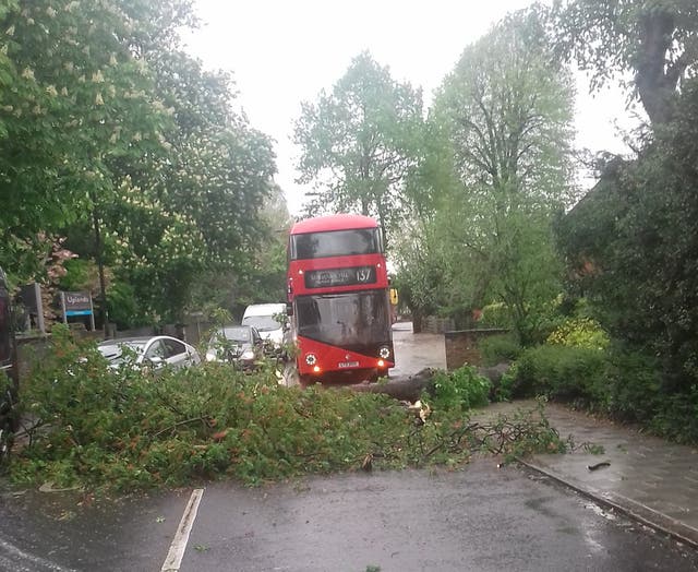
Pictures posted online showed fallen trees blocking roads in London, with tree surgeons disposing of one which had crashed through a wall in Ealing.
Elsewhere, a man was trapped when a tree fell on to his car in Herne Bay, Kent, on Monday morning.
Firefighters had to cut the roof off the vehicle before the man was seen by medical staff, Kent Fire and Rescue Service said.
Following the recent spell of warm weather, most trees are now in full leaf and this has led to casualties from today's high winds. The falling of this beautiful old horse chestnut has also taken down the much older boundary wall of #PitzhangerManor in #WalpolePark, #Ealing. pic.twitter.com/3ohTqtq2KR
— John Furzer (@JFurzer) April 30, 2018
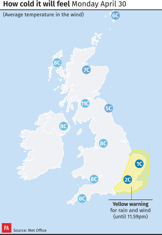
The soggy start to the week came with chilly temperatures, with a high of 8C (46F) forecast for London, 12C (54F) in Manchester and 6C (43F) in Norwich.
Cricketers in the Essex v Hampshire fixture even took to the pitch wearing woolly hats in an attempt to repel the unseasonably cold weather.
📸| It will get warmer @petersiddle403, we promise! 😨#HAMvESS pic.twitter.com/0RpEsHhhCG
— Essex Cricket (@EssexCricket) April 30, 2018
The North Downs between Kent and Surrey could see between 60-80mm of rain, compared with the April average for the area of 50mm, Met Office meteorologist Becky Mitchell said.
Northern and western parts of England, as well as Scotland and Ireland, should remain mostly dry with some sunny spells, the Met Office said.
Rainfall is expected to ease away from south-eastern parts on Monday night, with temperatures set to rise to the mid-teens, the Met Office added.
Clare Dinnis, flood duty manager for the Environment Agency, said: “Widespread heavy rain from Sunday evening and through Monday could lead to flooding from surface water and rivers in parts of south, south-east and central England.
“Strong winds will also lead to large waves and spray in exposed coastal areas and we encourage people to take care in these locations.
“We advise people to listen to their local radio stations and remember not to drive through flood water as just 30cm of fast-flowing water is enough to move your car.”


Comments: Our rules
We want our comments to be a lively and valuable part of our community - a place where readers can debate and engage with the most important local issues. The ability to comment on our stories is a privilege, not a right, however, and that privilege may be withdrawn if it is abused or misused.
Please report any comments that break our rules.
Read the rules here